Hi everyone, this is a very short post just to inform you that you can see more of my pictures on my new website: http://www.jfgout.com
I don’t always write a full blog post to go with the pictures I take. So you will find extra galleries, and also a better presentation on this website. I’m working on integrating the blog into the new photography website, so stay tuned!
The lunar eclipse of April 15th 2014 was the first of a series of 4 total lunar eclipses in two years, all of them visible from North America! My initial plan for this one was very ambitious, including a 10 days trip to Arizona and Utah and culminating with a very ambitious time-lapse of the eclipse from Capitol Reef. But as the eclipse was getting closer I realized I was not ready for it and decided to stay in Bloomington (Indiana) and gain experience on lunar eclipse photography. After all, I will have 3 other chances to take pictures of lunar eclipse in the next 2 years…
Unfortunately, the first forecasts (~10 days ahead) were not good for the mid-west. A week before the eclipse, I decide to buy a plane ticket to Denver, rent a car and go to Arches National Park in Utah, where the forecast is clear skies for the night of the eclipse.
The day before the eclipse I enjoy hiking in the park (Arches is amazing btw…) and go on the 3 miles (round trip) hike to Delicate Arch, my future observing spot for the eclipse. I had seen hundreds (if not thousands) of pictures of the arch before this trip, but no picture could prepare me for what I was about to see. This arch is simply magnificent. Unfortunately, the weather is changing and it is now pouring rain. I tried to use the iPhone app Theodolite to find the perfect spot for next night (= the spot where I can set my camera and frame the eclipse in the middle of the arch). The terrain is very steep and the rain makes it almost impossible to use the iPhone…
I still managed to snap a picture of the arch in these apocalyptic conditions:
Delicate Arch under the rain
On the plus side, there are very few other people there (this place can get packed with tourists!!!) and all this rain should clean the air, removing all the dust and giving us clear and transparent skies for tomorrow…
Eclipse day: I wake up super early to record a time-lapse of the sunrise, go hike in the park and head back to the hotel for a short nap and some food before the big event. Back to the park, I enjoy a wonderful sunset, immediately followed by the moonrise.
Sunset over balanced rock
Pretty much all the cars are stopped on the side of the road and everyone is trying to take pictures. The eclipse approaches, and I need to get ready. There are still a few cars at the Delicate Arch trail head. Mostly people coming down after enjoying the sunset from up there, but also a few cars belonging to fellow astronomers who are doing the exact same thing as me. I start the hike, carrying over 100 pounds (50Kg) of gear on my back. People look at me strangely when they see me struggling to go up the path with all this gear. I quickly begin to question my capacity to carry everything up. Maybe I was too ambitious… But after a number of pauses to give some rest to my back and my legs, I finally reach the bowl, where stands Delicate Arch. There are about 12 other people here, most of them with tripods and camera. I talk to some of them and then hurry up to go set up my own gear.
So, what was in this 100 pounds? Well, here is the list:
– 3 tripods
– 1 Orion ED80 refactor (the telescope)
– 1 Celestron CG4 equatorial mount (the device allowing the telescope to track objects in the sky) with accessories (counter wight of course, but also AD motor + controller + pack of batteries, …)
– 1 Dolly for the time lapse (Dynamic Perception stage zero) + 1 radian (for rotation of the camera)
– 4 cameras (Two Canon 350D, One Canon 5D Mark II and One Canon T2i that I borrowed to some friends)
– One laptop (to check the focusing and back up some images).
– A bunch of lenses for the cameras + spare batteries + small accessories
– Food, water, clothes for the cold and small stuff (phone, …)
It takes me almost 2 hours to set up everything and I barely finish in time for the beginning of the eclipse.
And now the magic begins. Slowly, the Moon disappears in the Earth’s umbra. The shadow of the arch on the ground gets fainter by the minute and stars in the sky are getting more and more numerous. I chat with another astro-photographer, check on my cameras and realize that the battery on the dolly had died (I charged it to full just before!!!) –> no time lapse with the dolly!
The totality is there, the Moon is now all red and all the photographers are getting really excited. Some of them use powerful lamps to ‘light paint’ the arch (without asking the other photographers if that could ruin their pictures… not very ethical in my opinion) and I keep making sure that my other time lapse (the T2i on the telescope) is going smoothly. From time to time I need to recenter the moon in the field of view (the tracking was pretty bad, I must have messed up the polar alignment of the mount), but nothing too bad. Someone drops a glass bottle. We can hear it going down the bowl and finally crashing at the bottom, some ~30 meters (~100 feet) bellow. Trust me, when you walk around the bowl at night you have to be careful and you definitely do not want to take the same path as this bottle!
When the light finally comes back on the other side of the Moon, most of the photographers start picking up their gear and leave before the end. I stay there with another astronomer from Minnesota who was taking a (very) long exposure of the full eclipse with a large format film camera.
The hike back to the parking was miserable, carrying all this gear, but I made it back to the car and then to the hotel.
Here are the pictures.
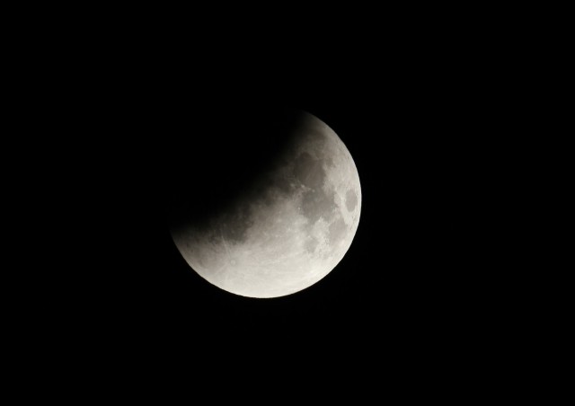
The Moon disappears in the Earth’s umbra
A few minutes before totality. Only a small fraction of the Moon is still lit directly.
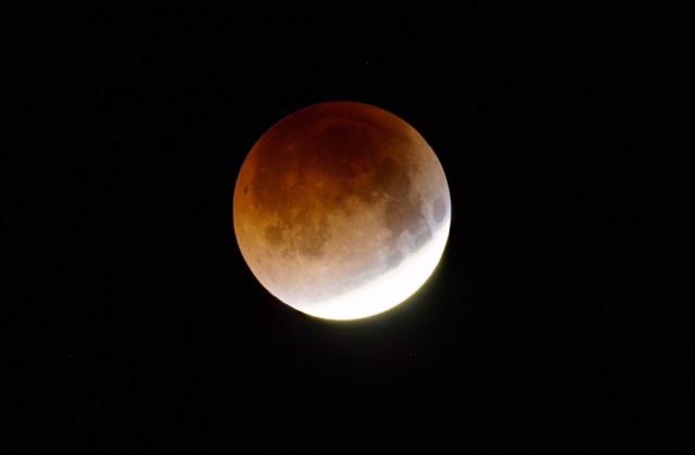
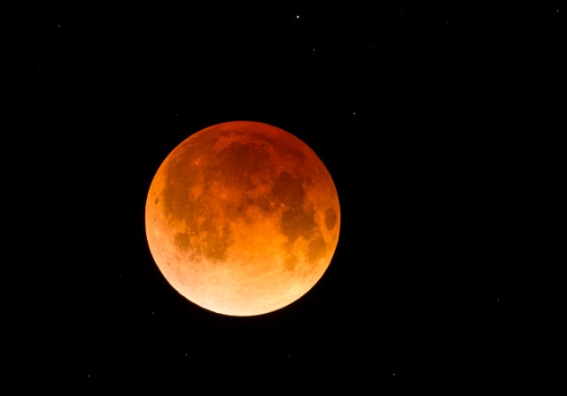
During totality, the Moon turns red.
The Moon in the sky above Delicate Arch during the totality
For this next picture, I was initially planing on getting the arch pitch dark (just like in the previous one) but with all the light painting going on it was impossible. In the end, I’m actually quite happy with the result:
The different phases of the eclipse seen through the arch
Delicate Arch as seen from another arch.
I’m still working on the video, so please be patient and hopefully some day the time lapse taken through the telescope will be available here…
The usual rule of thumb in eclipse chasing goes something like that:
A total solar eclipse is worth any and all effort (get ready to travel to the other end of the world!). An annular eclipse is worth a long drive or a short flight. And a partial eclipse is worth looking at if it is visible from your backyard.
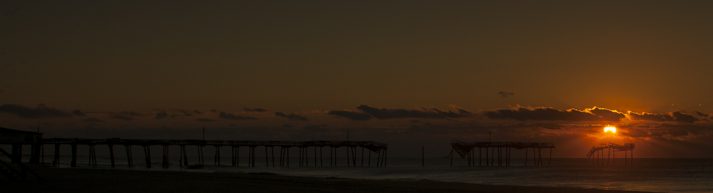
Well, that is not entirely true, as you will see in the case of this partial solar eclipse. On November 3rd 2013, some lucky people on boats in the Atlantic or on land in certain regions of Africa got to see a total solar eclipse (see: http://en.wikipedia.org/wiki/Solar_eclipse_of_November_3,_2013). For the rest of the world, the best we could see was a partial eclipse. However, from the East coast of the US, the eclipse would be ongoing at the time of sunset, making it possible to see a very unique sunrise.
I started planing for this trip about a year before the eclipse. The first step was to select a number of potential observing sites alongside the Atlantic coast and hope that at least one of these sites would benefit from clear skies on the day of the eclipse. This is where Google Maps comes in handy, allowing me to zoom and find potential spots, including lighthouses, bridges, iconic buildings, … My primary spot was the Frisco fishing pier (North Carolina). The pier was badly damaged by hurricane Earl in 2010 and pieces of it are now missing, making a perfect foreground for the pictures.
36 hours before the eclipse, I fly from Indianapolis to Raleigh. The weather forecast for Frisco, NC is pretty good so I wont have to drive 12 hours to one of my alternative observing spots.
24 hours before the eclipse: I’m on site, checking the parking and access to the beach. Everything looks fines, the Outer Banks is a beautiful place. It’s cloudy, but it should clear up sometime during the night. The weather forecast is slightly better for further south (South Carolina and Georgia) but I don’t feel like driving that far now that I’m on site.
4 hours before the eclipse: after a few hours of sleep, I check all the weather forecast websites a last time before heading to the beach. It’s still cloudy but some portions of the sky are showing a few stars and the strong winds are helping to clear up the skies.
I go to the beach, on the exact spot form where the sunrise will be lined up with the pier and wait… The skies clear up and I take a few pictures of the milky way.
The milky way over the beach, waiting for the sunrise.
Less than an hour before the sunrise: the weather forecast was correct, there is only about 5% of the sky that is occupied by clouds. But these clouds are exactly in the direction of the sunrise! I’m starting to regret my decision to not drive further south…
The sunrise approaches, and while I’m walking nervously on the sand, I notice a large dark band in the sky in the direction of the sunrise. I initially thought this was the shadow of the total eclipse (remember, for some parts of the Atlantic ocean the eclipse was total) projected on the atmosphere. Turns out, this was simply a crepuscular ray (see here: http://en.wikipedia.org/wiki/Crepuscular_rays).
Crepuscular rays, moments before sunrise
And after some more wait, it’s finally time for the sunset. But the clouds are still there, and I miss the first minutes of the spectacle 😦
And suddenly, the light intensifies, the Sun appears from behind the clouds. I quickly adjust the framing on my cameras, and start firing the first rounds of shots.
The Canon T2i is set up on the telescope (an Orion ED80, a short telescope that I can easily take with me on the plane) and the 5D Mark II is recording a raw video, using the special firmware magic lantern and a Tamron 70-300mm zoom. And while these two cameras are automatically recording images, I take another series of pictures with a Canon Rebel (350D). So, here is the result:
Concerning the video, I choose to show the spectacle at its (almost) real speed. So, no time-lapse speeding up the process. I know that most people wont take the time to watch a 3 minutes video of a sunset. But if you want to see this sunset pretty much the same way you would have seen it with your own eyes, just click ‘play’ and make sure you are watching full screen and High Definition! Oh, and make sure you have the volume up on your speakers (or earphones), my friends Iscaac Namias did a wonderful job with the music…
“The first man who will live 1,000 years has probably already been born”
Aubrey David Nicholas Jasper de Grey
“I don’t want to live 1,000 years, that sounds boring!”
Me
Introduction
On June 5th 2012 (or June 6th if you were in Europe), a very rare astronomical event was to be seen: a transit of Venus. In case you are wondering what it is: a transit of Venus is when the planet Venus passes directly in front of the Sun as seen from the Earth, becoming visible as a tiny black disc slowly moving across the face of the Sun.
Because the next one would not occur until 2117 (and I have no intention to live past 133 years…), I decided to get the maximum out of this one and I planned a trip to the West coast for the observation. A good occasion also to visit some friends in California and enjoy the wonders of the Golden State.
So, it’s from the Pacific coastline, some 50 miles south of San Francisco that I would go to witness this rendez-vous between Venus and the Sun. On june 5th/6th, for the 68th anniversary of the invasion of Normandy, I had my own rendez-vous with the Sun and Venus on a small parking, wedged between the mythical highway 1 and the Pacific ocean, facing the tallest lighthouse on the West Coast (Pigeon Point lighthouse). By the time the Sun was setting on the Pacific, I had spent 8 amazing hours on this parking and I was thinking about the fact that 20 minutes later the Sun would rise on Lyon (in France) for the beginning of a very important day: my nephews first birthday!
Here is the story of these 8 legendary hours and everything that led to it…
A little bit of history…
Introduction
Looking up at the sky, there is no way that you’ve never been amazed by the beauty of a starry night sky, the breathtaking colors of a sunset or the mysteries of a full moon illuminating the landscape. But have you ever wonder how astronomers managed to understand what was happening in the sky? How did they calculate the distance from the Earth to the Moon, from the Earth to Sun and then to the stars and galaxies in our universe? It all really started when Erastosthenes used the difference in the angle of the elevation of the Sun between two different cities in Egypt to calculate -with a remarkable precision- the circumference of the Earth. After that, astronomers often relied on specific astronomical event such as lunar eclipses to estimate the distance from the Earth to the Moon and then from the Earth to the Sun and every other planet in our solar system. By the beginning of the 17th century, more than 1,800 years after Erastosthenes and while the renaissance had brought new life to science all across Europe, the distance from the Earth to the Sun was still not know with a good precision. But this was about to change…
The first scientific observations
On December 4th 1639, Jeremiah Horrocks became the first astronomer to observe a transit of Venus (http://en.wikipedia.org/wiki/Transit_of_venus). Horrocks observations allowed him to estimate the distance between the Earth and the Sun to be 95.6 million km, a much more precise number than the ~7 millions km estimated by Aristarchus of Samos almost 2,000 years before, but still quite far from the actual distance (149.6 million km).
After that, observations of the transit of Mercury were used to estimate the distance from the Earth to the Sun but the results were disappointing. Then, in two papers published in 1691 and 1716, Edmond Halley (yes, the same guy that Halley’s comet was named after. He predicted that the comet sightings of 1456, 1531, 1607, and 1682 were related to the same comet and predicted the return of the comet for the year 1758. He was right but died before he was proven correct) proposed that more accurate calculations could be made using measurements of the upcoming transits of Venus. But the next transits of Venus would not occur until 1761 (and then 1769) and Halley did not live long enough to see them (story of his life)… Although Halley was not there anymore, numerous other astronomers and explorers (including the famous James Cook) went on expeditions all around the Earth to observe the transits of 1761 and 1769. The calculations were not as precise as they have hopped but French astronomer Jérôme Lalande managed to use the combined 1761 and 1769 transit data to estimate the distance from the Earth to the Sun to be about 153 million km (remember, the actual distance is 149.6 million km), a much more precise estimate than anything that had been published to date. The observations by Mikhail Lomonosov from the Saint Petersburg Observatory also led to the conclusion that Venus had an atmosphere, which was a big discovery.
If the expedition led by James Cook was probably the most successful one (more for his explorations than for the actual observation of the transit of Venus which was rather imprecise), others did not have his chance…
The most unlucky astronomer of all time
Guillame Legentil (Guillame Joseph Hyacinthe Jean-Baptiste Le Gentil de la Galaisière if you want the full name…) was one of the ~120 astronomers who observed (or at least tried to observe) the 1761 transit of Venus. On March 16th 1670, he sailed from Brest (Brittany, France) to Pondichery, a French colony in India to observe the transit of Venus. But before his ship arrived, war between England and France had broken out and it was not safe to land in Pondichery which was disputed between the two countries (dam Britts!!!). Legentil had no choice but to return to Mauritus, his previous stop on the way to India. However, the winds were not favorable. They did not make it in time to Mauritus and Legentil had to observe the transit from the deck of the ship, preventing him from making any precise calculations. But Legentil did not get discouraged. He decided to stay in the South hemisphere until the next transit: 8 years latter. He spent some time mapping the East coast of Madagascar and decided to observe the 1769 transit from Manilla, in the Philippines. But in 1767, after a peace agreement between France and England, he was recommended by the French government to return to Pondichery where he arrived in March 1768. There, he built an observatory and patiently waited for the upcoming transit in June 1769. The day of the transit finally arrives! The weather has been perfect so far, but shortly before the transit starts, clouds came rolling in and blocked the view during the entire duration of the transit. An hour latter, the sun was shining again… And guess what: the weather was perfect for the whole duration of the transit in Manilla (where he initially wanted to be for this observation). But wait, story is not over… While he was getting ready to sail back to France his ship was delayed due to dysentery and then captured by a storm. Le Gentil had to go a shore at île de la Réunion (a small French island, East of Madagascar) and wait until a Spanish ship brought him home to France. In 1771, 11 years after he left France, he finally made it back to Paris … only to find out that he had been declared legally dead, his wife had remarried and his relatives had divided the assets between them.
In the end, he got his job back, remarried and lived happily (or at least we think he did) for the next 21 years. But still, what an adventure … and an adventure good to remember when I get worried about missing my connecting flight in Denver, on the way to the West coast for my own expedition to observe the 2012 transit of Venus.
If you are interested in the history of astronomy, I strongly recommend this amazing book by Simon Singh: ‘Big Bang: The Origin of the Universe‘ Reads like a thriller!
Planning my own expedition for the 2012 transit of Venus
The transit was visible from anywhere in the US, but the more North-West you would go, the longer you could enjoy it. From Bloomington, the Sun would be already quite low on the horizon by the time the transit starts and I could observe it for only ~ 2 hours before sunset. So, I decided to go on the coast of California where I could enjoy ~5 hours of transit + a unique sunset on the Pacific (while the transit is still ongoing) + high probability of clear skies. It was also a good occasion to go visit my friends in San Francisco and Santa Cruz.
A week-end in San Francisco
On Friday June 1st, I leave the lab in the afternoon to go catch my flight in Indy. After a short layover in Denver, I arrive at the SF International Airport at 11pm, just in time to catch the last BART (= the local metro) to Berkeley. Bastien and Mathilde are waiting for me at the BART station in Berkeley and they help me to carry all my stuff (>100 pounds / 50Kgs of luggages) to their apartment. I haven’t seen them in 2 years, so we have tons of stuff to talk about but it’s already past 1am (= past 4am on the East Coast), time for me to go to bed. Saturday was a typical tourist’s day in San Francisco: wandering in the district of the mission, taking pictures of Maxime Le Forestier’s blue house (French people will understand), crossing the Golden Gate Bridge in the fog… It was also the occasion to see my friend Holly (see: Climbing mount Fufi … in my very own way).
After a good diner at Revival (a really nice restaurant in Berkeley) with my friends and a good night of sleep I was ready for a second day of wandering in San Francisco. This time I will be by myself but I borrowed Mathilde’s bike so that I can more easily go from one district to the other. Biking in San Francisco was one of the biggest highlights of this trip! Everything is so much easier with a bike. From the BART station ‘Embarcadero’ it will take me less than 10 minutes to go to Fishermans wharf, where I will have lunch with Manu, another of my friends from Lyon who is now living in San Francisco with his wife and their two daughters. After lunch I have an hour to kill before going to Alcatraz and I decide to go biking down the legendary Lombard Street. But of course, one needs to earn this pleasure by biking up one of the streets leading to Lombard Street. I started biking on Hyde street from the piers and trust me: it’s very steep! While I was struggling to keep going on it’s almost 30° grade slope, people in the streetcar ahead of me and on the sidewalks started cheering on me to help me and some of them even took pictures (I guess they don’t see that many crazy bikers going up these very steep streets). I had the feeling to be a professional cyclist in Le Tour de France … great feeling! After this intense effort I’m rewarded by taking a left turn on Lombard street and biking down this legendary street.
Lombard street
Five more minutes of biking and I’m at pier 33 where I will take the boat to Alcatraz. The visit of Alcatraz is really interesting, with a great audio guide. This place has such a rich history, and not only because of the jail but also because of it’s pre-jail history and of course the occupation by Indians of all tribes (see: http://en.wikipedia.org/wiki/Occupation_of_Alcatraz)
After the visit of Alcatraz I quickly go to the pier #39 where a colony of sea lions are happily sun bathing and pose for tourist to take pictures. These animals are really awesome. If reincarnation is true, then I want to be a sea lion in my next life 🙂
Two days in Santa Cruz
After saying good bye to the sea lions, I go back to Berkeley where Bob will pick me up to go to Santa Cruz. Time to say good by to Bastien and Mathilde. On the road, Bob and I can enjoy a beautiful moon rise. I try to take some pictures from the car but did not quite manage to capture the beauty of this moon rise.
Moon rise over the Shipping Container Cranes of Oakland port (according to the legend, this is what inspired George Lucas for the Star Wars AT-AT Walkers)
We arrive in Santa Cruz just in time to go grocery shopping before the store closed and after a diner made of sushis, cheese and pizza I go to bed while thinking: “will I have the courage to get up at 4 am to take pictures of the partial lunar eclipse?” (yes, there was also a partial lunar eclipse that night … so many astronomical events in such a short amount of time!). Well, I was too tired to take pictures, and anyways, in the middle of the night the clouds started to fill the sky.
On Monday I spent most of my time on the UCSC campus, trying to work on my laptop from the biology building while it was pouring rain outside. In the evening it finally stopped raining and we went for a nice trail run with Bob and one of his friends before heading downtown for diner with Bob and his girlfriend: Jaime.
Transit day!
Tuesday: finally the day of the transit has arrived! Blue sky, good weather forecast, I know it’s gonna be great. Bob has to go work in the lab but Jaime gave me a ride to my observation spot, a parking off highway 1, about 20 miles North of Santa Cruz (Gazos Creek State Beach to be precise: https://maps.google.com/maps?q=37.166447,-122.36171&ll=37.166199,-122.359827&spn=0.002125,0.004801&num=1&t=m&z=18). Why this place? Because from there the sunset would be perfectly aligned with the Pigeon Point Lighthouse, located about 2 miles North-West. That should produce dramatic views of the sunset. I set up my telescope on the almost empty parking, show the sun through the h-alpha telescope to Jaime and to the other people parked there and wait for the transit to begin, in about one hour.
Jaime standing by her car while I’m finishing to set up the telescope.
View in direction of Pigeon Point Lighthouse
360° view from my observation spot
Jaime has to go for a job interview and I’m now alone with the Pacific ocean, waiting for Venus to begin its spectacle. I love this atmosphere. The wind is blowing without any interruption and I think about all these explorers from the 18th century who traveled for years to observe the same thing.
3pm: the transit should begin soon. I start taking pictures with a camera dedicated to making a time-lapse movie of the event (the camera with the big zoom that you can next to the telescope on the next pictures).
After a couple of minutes I can see it through the telescope: a tiny incisure on the edge of the Sun, rapidly growing until the entire surface of Venus is in front of the Sun, giving the visual impression of a small hole in the Sun. I keep starring at this tiny black disc, slowly moving across the face of the Sun. From time to time I set up a second camera to take pictures through the telescope but my focus was always a bit off.
Photo montage showing the progression of the transit over ~4 hours
And here is the time-lapse showing the progression of the transit:
From time to time a car would stop. I offer people to look at the transit through the telescope and I even spent half an hour helping a guy to take pictures with his own camera (I had an extra solar filter that I somehow managed to fit on his camera). Sometime around 6pm Bob and Jaime join me for the end of the observation.
7.30pm: less than an hour until sunset, I turn off the camera that was taking pictures for the time-lapse movie, unmount the telescope and get ready for the sunset pictures. I set up two cameras to automatically take pictures from the beach where Bob and Jaime will enjoy the sunset while I run to the other side of the parking with a third camera to take pictures from the place where the Sunset will be perfectly aligned with the lighthouse. Five or six other people are there, taking pictures. The sun gets low on the horizon and I can feel the tension rising among the other photographers. Will these clouds block the view at the critical moment of the Sunset? Well, the pictures below should answer the question…
See the tiny black spot on the Sun (bottom-right) ? It’s Venus… I strongly recommend you click on the image and then on the link to the full resolution picture.
For those of you too lazy to click on the image and go see the full resolution picture, here is a crop centered on the Sun:
From the beach, the sun was setting at the left of the lighthouse as you can see on this time-lapse video:
But the spectacle was beautiful, with the sand changing colors from dark brown to glowing gold while the sun passes across the clouds (full screen HD strongly recommended for this video):
The night is falling, I hurry up to get all my equipment into the car and we head back to Santa Cruz for a great sushi diner with Bob. Back to Bob’s house I have to pack everything in my suitcase and my mountaineering bag (every time I travel I have to unmount the telescope in many pieces so that it fits in the suitcase…) and go to bed as soon as possible. Tomorrow I’ll have to get up at 6am to go catch my flight at the San Francisco airport, going back to Bloomington and already dreaming of some new adventures.
I know it’s gonna be hard to get back to work, thousands of miles away from the coast, especially after witnessing such an amazing sunset…
On May 20th 2012, an annular eclipse of the sun was visible from China, Japan and parts of the West in the USA (see this map). For those of you not familiar with it, an annular eclipse of the sun is when the Sun and Moon are exactly in line, but the apparent size of the Moon is smaller than that of the Sun. Hence the Sun appears as a very bright ring, or annulus, surrounding the outline of the Moon (definition from Wikipedia).
From Bloomington, Indiana we would see only a partial eclipse, with ~40% of the sun being covered by the moon just before sunset. To see the unique spectacle of an annular eclipse, I flew 1,500 miles away, drove almost a thousand miles, carried about 200 pounds of stuff (telescope, tripods, cameras, …) for about 1 mile on a trail at 10,000 feet elevation and took over 4,000 pictures to share with you.
A very long preparation, a lot of efforts and guess what … it was worth it!
And if you are wondering: “why so many pictures?”. Well, the answer is: so that I can make time-lapse movies, like this one (HD link: http://youtu.be/SxKcPXVoufg?hd=1)
Part one: before the eclipse
The preparation
After spending hours to search for the best location to view the eclipse I decided to go to Albuquerque, New Mexico and observe the eclipse from Sandia Peak, a 10,000 feet high mountain offering amazing views at the western horizon. Because the eclipse would still be ongoing at sunset, it was important to find a clear (and if possible) beautiful west horizon. Alternative observing spots (in case of bad weather forecast for Albuquerque) included Page, Arizona and Canyon de Chelly National Monument, Arizona. Lake Powell, Horseshoe Bend (Glen Canyon) or Canyon de Chelly would have been beautiful places to visit. But from there, the eclipse would be almost over at sunset, preventing me from taking THE picture of the eclipsed sunset that I’ve been dreaming of.
April 7th, 2012: I book my flight to Phoenix, this trip is starting to be real! Phoenix is only a 7 hours drive away from Albuquerque and it offers cheap direct flights from Indianapolis. It’s also a convenient location if I need to change my observation spot due to bad weather forecast (Page, AZ is only 5 hours drive away) and it’s a good occasion to go visit Maria, a friend of mine who is currently living in Phoenix.
From Bloomington, IN to Albuquerque, NM
On Friday (May 18th, 2012) I leave work early in the afternoon to catch my flight. From the plane, after about 2 hours of flight, I can see Albuquerque and the Sandia Peak mountain, my future observing spot! Hum, it’s kind of cloudy today, let’s hope that in two days we will have a better weather.
After we have passed Albuquerque, the views from the plane became just incredible. All this land is absolutely empty and dry. All you see is a desert landscape with canyons, red soils and from time to time a little bit of green. Approaching Phoenix, I can see some of the forest fires that Arizona is currently enduring, then the mountains and finally the city of Phoenix itself is there.
After getting my checked luggages, I go rent a car and wait for Maria who was flying back from North Carolina. Her plane lands at midnight, so we did not went home until 1am … That’s the beginning of a long series of sleep deprivation!
On Saturday afternoon, after watching the soccer game (champions league final, both Maria and I are soccer fans so we could not miss this game…) we hit the road, direction: Albuquerque. The weather forecast is not perfect (~30% of clouds coverage at the time of the eclipse according to www.wunderground.com) I’m starting to get stressed. Should we go to Page, AZ instead of Albuquerque? Let see what the weather forecast says tomorrow, the eclipse is in the afternoon, so there is time to drive from Albuquerque to another place…
We arrive in Albuquerque at 1am, check in at the Best Western Executive suites and go get some sleep.
Part II: Eclipse day: gambling and winning…
Sunday morning, after a detour to the Hard Rock Casino and Hotel (Maria collects the Hard Rock Café souvenirs) we go in direction of Sandia Crest, our observation spot. The weather forecast is still calling for ~30% of cloud coverage in the afternoon and we still have time to go to an alternative observing spot with a better weather forecast (Page and Canyon de Chelly both had much better weather forecast). But after spending one dollar in a slot machine at the Hard Rock Casino, I feel like a gambler and I bet that the clouds will not block the view from Sandia Crest.
The road to the top of Sandia Peak is an enchantment, especially after the highway across Albuquerque (not really a beautiful city in itself). At noon, we park at the end of road, on Sandia Crest, at about 10,000 feet (~3000 meters) elevation. From there, the views are amazing. The main viewpoint is already occupied by some astronomers with telescopes and camera but this is not a problem to me, the spot I want to observe from is about a mile away, at the Kiwanis cabin. Maria and I start hiking in direction of the Kiwanis cabin and we can enjoy some beautiful aerial views along the trail.
At the Kiwanis cabin, we climb on the roof of the cabin and start setting up the equipment on the North-West corner of the roof, the best one to view the eclipse. I have to go back to the car twice to bring all the equipment (5 tripods, 1 telescope, 4 cameras, …) and set up everything. It is ~2pm and from time to time some clouds block the view at the sun but I’m not worried, it’s gonna be clear sky at the time of the eclipse, it has to be…
More and more people are passing by, some of them take a look at the sun through the telescope (when the clouds allow it), the wait for the eclipse has started.
Waiting for the eclipse…
The eclipse will not start until 6.30pm, so we have plenty of time and we start talking with Amanda and Alex, two super nice persons that we met on the roof of the Kiwanis cabin. That’s the great thing about the eclipse, it brings together people from different horizon and it’s a great opportunity to meet new people. I must admit that Amanda even becomes my favorite person in the World when she takes out of her bag a bottle of Porto to share with us. Sometime around 5pm, the park rangers come tell us that it’s not safe to stay on the roof of the cabin, so we have to get all the equipment down. No big deal, I still have plenty of time to (re) setup everything before the eclipse starts and the view from the ground is almost as good as from the roof of cabin.
And time starts moving faster…
6.28pm, Maria who was looking through the telescope shouts out: it’s started ! I can see it!!! Quickly after that, the portion of the Sun that is obscured by the Moon has became big enough to be visible with the naked eye (through the eclipse shade of course). I can feel the excitement growing among the dozens of people looking at the eclipse around us. With the telescope we can see not only the surface of the sun, but also the protuberances (solar flares) being swallowed slowly by the Moon as it keeps moving across the Sun. At some point I remove the eyepiece and attach the camera to the telescope to take pictures. However, it goes so fast that I don’t want to waste too much time adjusting the focus (it can take dozens of minutes to achieve a good focus through the telescope), so please forgive me if these pictures are a bit blurry.
The Moon now covers about 50% of the surface of the Sun and with the telescope we can easily see the relief on the edge of Moon. As we approach the totality, time moves faster and faster. It feels like the eclipse started a minute ago but it’s actualy almost 7.30pm and the Sun is now a magnificent, thin cresent of light.
The ring of fire
A couple more minutes to go, and the Moon is entirely in front of Sun, giving to the Sun the shape of a ring of fire. People start applauding and cheering, that’s the spirit of an eclipse. The ring of fire is there for only 4 minutes and I try to enjoy the view through the telescope but also to take some pictures. To me, the view through the simple eclipse shades is the best. Just the Sun, the Moon, and my eyes… The feeling is hard to describe but trust me, it’s powerful.
And it’s already the end of the ring of fire, the Moon keeps moving and it’s now a growing crescent of Sun that we can see. Most people leave and hike back to the parking… They don’t know that they will miss the best part of the spectacle: the sunset while the Sun is still partially eclipsed.
A magical sunset
For the sunset, we can remove the eclipse shades and enjoy the views of the partially eclipsed sun directly with our eyes. I have 3 cameras taking pictures automatically (with a remote control) and use a 4th one to take more pictures with varying the settings. We can hear the crackling of the cameras taking the pictures. Only a couple of minutes left before the Sun disappears behind the slopes of Mont Taylor in the distance. Maria and Amanda want to take pictures of us with the sunset in the background. I move the tripod backward and try to fit both us in the foreground and the sunset in the background but in the precipitation we end up blocking the view at the sun on most of the pictures 😦 Still, I manage to get some okay pictures of the eclipsed sunset with in the foreground the silhouettes of Amanda, Maria and Alex. Mission accomplished!
To finish, here is a collage, showing the different parts of the eclipse over Albuquerque. I did cheat a little bit for this image by rotating the camera a few degrees to the South for the foreground image (in other words, the actual sunset was a bit more on the right side, just out of the field of view). Next time I’ll do a better job at planning these things!
Back to reality…
The sun is now behind the horizon, it’s time to pack all the equipment and bring it back to the car. It’s getting really cold but I’m way too excited to feel it. With the night falling we can now see Venus shining above Albuquerque. The city lights are dancing in the distance, I take a last pictures for the photo montage and with the help of Amanda we manage to bring all the equipment back to the car at once. It’s now time to say good bye to Amanda, and get back on the road. At 5am, we are back in Phoenix, exhausted but happy.
After a couple of hours of sleep, a quick lunch with Maria and her friends, it’s time for me to say good bye, go back to airport, and fly back to Indianapolis with my head full of memories.
Acknowledgments. I’m really lucky to have such amazing friends who made this trip possible. Thank you Maria for hosting me in Phoenix and for sharing these unique moments with me. Thank you Amanda and Alex, it was great meeting you guys and sharing some Porto (and good memories) with you. Thank you Erkin and Kristin for lending me your cameras. And thank you Lydia for picking me at the airport at almost 1am!!! You guys rock.
Some pictures from the last solar eclipse that I witnessed on March 29th, 2006. It was very cloudy in France on that day, let's hope the weather will be better in New-Mexico this time.
On May 20th, 2012, an annular solar eclipse will be visible from North America. Because the distance between the Earth and the Moon varies (from around 356,400 km to 406,700 km), the apparent diameter of the Moon is not always big enough to cover the entire Sun during an eclipse. So, when the Sun, the Moon and the Earth are perfectly aligned but the Moon is too far away from Earth, for a couple of minutes the Sun turns into a ring of fire.
And that’s exactly what is going to happen on May 20th, 2012 on a path going from the North of California / South of Oregon to Texas. Probably the best thing about this eclipse is that it will be visible from some of the most amazing places in the west: Grand Canyon, Glen Canyon, Pyramid Lake (Nevada), Zion National Park, Bryce Canyon, Monument valley, … The hardest part will be to choose where to go.
Another great thing is that, in New-Mexico and Texas, the maximum of the eclipse (maximum = the moment when the Sun forms the ring of fire) will take place shortly before sunset, so that it could be possible to see something like that:
My plan is to flight from Indianapolis to Phoenix, rent a car and drive to the path of centrality of the eclipse (see: http://eclipse.gsfc.nasa.gov/SEgoogle/SEgoogle2001/SE2012May20Agoogle.html). Phoenix is ideally located to drive to different observation spots, from New-Mexico to Utah (or even Nevada if necessary), depending on the weather forecast the day before the eclipse. Plus, it will be a good occasion for me to see a friend who left Bloomington for Phoenix last year.
I’m really excited to go back in the west, discover some new places and hopefully enjoy one of nature’s most beautiful spectacles (and take some good pictures of course). So stay tuned, by the end of May I will have some stuff to tell on this blog !
Warning!Dear reader of the English version of this blog, please keep in mind that English is not my native language and forgive me for the poor grammar/style of my English writing. If you speak French, I strongly recommend you read the French version that is available here.
It’s not the destination, but the journey …
The road of life twists and turns and no two directions are ever the same. Yet our lessons come from the journey, not the destination.
Don Williams, Jr.
Focus on the journey, not the destination. Joy is found not in finishing an activity but in doing it.
Greg Anderson
Still, it’s better to have a cool destination.
Jean-François Goût
For the second note of this blog, after climbing Mount Fuji in my very own way, I’m taking you with me on a road trip across the USA, from Bloomington (Indiana) to Mayhill (New Mexico). Relax, fasten your seat belt and follow me on this 8-day journey that involves 2,700 miles (4300 Km), 3 time zones, two and a half telescopes and two feet of snow.
Introduction: Why a road trip to New Mexico ?
When I realized that I could not go home for Christmas (it would have taken too long to get a new Visa) I decided that this year –unlike the two previous ones- I would not stay in Bloomington for Christmas break. For those of you who don’t know Bloomington, it’s a great place to live, I have some amazing friends here, but for Christmas everyone goes home and the city becomes empty and sad (unless you like talking to squirrels, who are basically the only living creatures you will met in the streets of Bloomington around Christmas time). Because I love star gazing, I decided to find a place where the sky is beautiful and the night is dark, far away from the cities and their light polluted sky (http://www.darksky.org/). Since my first telescope (a 60mm refractor offered by my grand-father when I was not even 10) I’ve bought quite a few telescopes and kept dreaming of bigger telescopes and better skies. So, when I discovered that a place called New Mexico Skies (yes, it’s in New6mexico, how did you guess?) offered a 30-inch telescope (the kind of telescope that costs several thousands of dollars to buy …) for rent under one of the best skies in the USA it was obvious that this was the place for me to go on Christmas break. By the end of July, everything was planned: I would go to New Mexico Skies, stay there for two nights (Dec 26 and 27th), rent their big telescope for one night and use my own telescope (a 10-inch dob) for the other night, do some more star gazing on the road, visit some cool stuff in New-Mexico, stop on the way in Oklahoma City to visit my friends Zach and Leigh, stop on the way back at Clayton Lake to see the fossilized dinosaur tracks and do some more star gazing and finally go back to Bloomington just in time to celebrate the new year with my friends . Sounds like a solid plan. And guess what? Almost all of that happened…
From Bloomington to Mayhill
Friday, December 23rd 2011, it’s 3pm and I’m waiting for someone from enterprise rent a car to come pick me up so that I can go get the car that I rented. Everything is ready, I have a ton of stuff to load in the car. Camera and lenses? Check. Telescope accessories? Check. Tons of music CDs to listen while driving? Check (thanks Seb and Cécile for lending me these CDs. That helped a lot to pass the time while driving). As I said, everything is ready.
While skyping with a friend, I double check that I did not forget anything and start to feel extremely impatient about hitting the road. Finally, the driver is there and takes me to the rental agency. Bad news: they are out of GPS, but hopefully the North branch has one left that I can have. By 3.40pm the car is loaded, I head to the North branch to get the GPS and by 4pm I’m on the road to Oklahoma City. On this first day of travel I can enjoy a beautiful sunset while driving through the South of Illinois, the skyline of Saint Louis by night and the crazy Christmas illuminations of Santa’s Magical Kingdom in Eureka, Missouri.
Nothing really exciting until I enter the state of Oklahoma. I was about 500 miles away from Bloomington, somewhere in Oklahoma, when I suddenly realized that I forgot something very important: the mount of my telescope! In other words, I’m carrying a telescope that is totally unusable, useless… Well, don’t panic, I will have 24 hours in Oklahoma City to find a solution…
And now a piece of advice for travelers: if you stop in Stroud (Oklahoma), do not go to the Sooner Motel unless you like cold and dirty motel rooms with no hot water. OK, I like to complain, but at least it was cheap, I had internet access and I was just an hour away from Oklahoma City, so I was happy anyways.
It gets complicated …
Saturday, December 24th. I get up in my cold motel room, check out and get on the road again. The morning light illuminates the plain covered with a thin layer of frost. After spending most of the time driving at night the previous day, I really enjoy this view. It’s 10am when I knock on the door of my friends’ apartment, just in time for breakfast. Unfortunately, I don’t even have time to take off my coat that my cell phone starts vibrating: it was New Mexico Skies calling to tell me that they had a lot of snow over the past couple of days and that, as a consequence, they could not get the telescope out. On top of that, the last 1.5 miles of road leading to the observatory are covered with snow and I could never drive through it without a 4 wheeler. We agreed that I would call them back the next day to figure out what to do. At this point, I started to fear that this entire road trip would become a disaster. I could not even use my own telescope somewhere on the road since I forgot the mount. With the help of my friend Zach I tried to find a telescope mount for rent in Oklahoma City … without success. In the end, I decided to postpone my stay at New Mexico Skies by one day so that they would have more time to remove the snow. I was actually ready to help them, spend couple of hours shoveling some snow if that could help. And as for the road issue, I could always park the car and hike the last 1.5 miles.
Christmas in Oklahoma
Living abroad is awesome, but it also comes at a cost and has a couple of drawbacks. The first of them: being far from your family. It is inevitable, at times you feel homesick. And the worse time of the year for that is of course Christmas. When everyone goes home to visit their family while your family is on the other side of the ocean, it’s important to have good friends who can become your adoptive family for a couple of days. And because I’m a lucky bastard, I have such friends!!! Spending Christmas with Zach and Leigh and their families was simply awesome. On the menu: deep fried turkey, chugging beers (in each others face, of course), the best beef meat I ever had, tons of good food, lots of cheerfulness … everything I needed to forget the reality that I was several thousand kilometers (yes, that’s also several thousand miles) away from home and feel good. And since the sky was clear, we even used my solar telescope to look at the solar flares (no, I did not forget the mount for this telescope, and no, I could not have used this mount for the big telescope, it is way to small).
(And I’m waiting on Zach to send me the pictures of the deep fried turkey).
From Oklahoma City to Mayhill
Monday, December 26th. After two awesome days in Oklahoma City, it’s time for me to get on the road again. I have a ten hours drive to go to Roswell, the last big city on the way to Mayhill. I did not see any flying saucer nor any aliens but I enjoyed the beautiful conjunction of Venus with a thin crescent of moon just after sunset.
While I was parked at the New Mexico tourist information center to take pictures of the Moon and Venus, I call New Mexico Skies to find out about the situation with the snow. Answer: everything is fine, the telescope’s platform is clear and so is the road. I won’t even have to shovel snow (not even funny). I can now finish the drive to Roswell on an icy road, knowing that this journey will not be a failure.
By 9pm I’m in Roswell, and this time I choose the Super8 motel (which is a palace compared to the Sooner motel). I did not have much time to visit Roswell, but just driving on main street you will quickly realize that aliens are the big attraction here. Flying saucers and aliens are everywhere, even on the parking of my motel.
Tuesday, December 27th. Mayhill is only two hours drive away from Roswell. I have time to go visit the White Sands National Monument before going to the observatory. The dunes are partly covered in snow and kids enjoy sledding on the slopes while I hurry up to take pictures.
After leaving White Sands, I drive trough a beautiful mountainous area, pass Cloudcroft (the last village before the observatory) and its ski resort, to arrive at New Mexico Skies in the middle of the afternoon.
I quickly felt in love with this place. The sky is pure deep blue, the mountains are covered in snow, all you can see when looking around is telescopes domes, trees and snow… My cabin is very cozy, everything is perfect!
At 7pm, I meet Lynn (the boss) on the observation deck and she explains to me how to use the big dobsonian telescope (the big 30-inch telescope was not available, it was so cold that the electronic in this telescope would fail during the night, so I had to use the other Dob which is a 25-inch telescope).
As soon as the explanations are over I rush to take pictures of the moon which is setting behind the mountains in the distance. The view is just amazing (see the pictures below).
And when assembling all the pictures in a time-lapse, we can make a short movie of this moon set:
After that, I set up my camera with its fish eye lens on a tripod to take pictures of the milky way while I’m enjoying the views at the nebulae, galaxies and star clusters trough the telescope (the big telescope I was renting was dedicated to visual observing, it was not possible to take pictures with this one because it does not have a tracking device).From time to time I go check that everything is fine with my camera which is automatically taking pictures on its tripod, just a couple of yards (~ a couple of meters) away from the telescope. To make another time lapse, my camera took a first set of 310 pictures, each of them being a 40 seconds exposure time, covering a total of 3.5 hours of the night sky’s rotation. Here is the result (to be viewed in full screen and HD please):
You can see several planes going through the sky and also -if you look very carefully- a shooting star in Orion (in the upper right corner) at 14 seconds.
I made another series of 367 pictures with a different orientation (facing the West this time, the first time lapse was facing the Est) and in which you can see me in the foreground, using the big telescope before parking the telescope and going to take a nap (while the camera kept taking pictures):
My initial plan was to sleep 3 hours and come back to use the telescope for another two hours before dawn. But I was so tired, that I simply went to turn off the camera and went back to bed.
For the second night of star gazing,I will rent again the telescope from New Mexico Skies and try to do both visual observations and take pictures. But this time, I will use my CG4 equatorial mount (the small mount that I use for the solar telescope but which is to small to carry my big telescope) so that I can track the objects while taking pictures of them. Like that, I can take really long exposure shots that will reveal the very faint stars and nebulae. I won’t give more details about astrophotography, this is not the place. Just keep in mind that taking pictures of the deep sky objects is quite challenging.
Here are the results. All these pictures were taken with a Canon eos 350d modified to have an enhanced sensitivity to hydrogen alpha. Let’s start with the famous horse head nebulae (addition of 110 pictures, each of them being a 1 minute exposure time, Tamron 70-300 zoom lens on 300mm).
The great Orion nebula, aka M42 (addition of 72 pictures of 4, 12 and 30 seconds, Tamron 70-300 at 300mm):
Now let me show you something cool on the series of pictures I took of this nebulae. I was not expecting this, but on most of the pictures you can see the traces of geostationary satellites. While the equatorial mount was tracking the stars to compensate the rotation of the earth, the position of the satellites relative to the background sky was changing so that they appear as faint lines on these pictures. On the next 4 pictures, you can see 3 of them passing in front of the Orion nebulae (3 parallel lines in the pictures). Just keep in mind that these guys are orbiting ~36,000 Km away… You will probably need to look at the full resolution pictures to see the satellites.
The next picture is the entire constellation of Orion, with the Barnard’s loop, a very faint nebulae that circles the left side of Orion. Try to find the horse head nebulae and m42 on this pictures (they are there, but appear much smaller because this picture was taken with a 50mm lens).
I also quickly saluted the seven sisters (the Pleiades), although I did not have to much time, so the picture clearly lakes exposure time to have more signal:
And to finish, let’s have a look at the milky way before it sets behind the mountains of New-Mexico:
The next one shows the setup that I used to take the pictures. Note the cardboard box. It contains the batteries to power my equatorial mount and they are wrapped in a shirt + a winter hat + a sweater to protect them from the cold.
That night, I went to bed at ~4am with the eyes full of images of galaxies, nebulae and star clusters … and also knowing that the memory card of my camera was also full of cool images. I would have loved to stay up until dawn, to see more deep sky objects that were still too low on the East horizon but I needed to get some sleep for the 10 hours drive I would have to do to go back to Oklahoma City.
Back to reality
Thursday, December 29th, I leave New-Mexico Skies in the morning with only one thing in mind: I want to come back!!! On the road I realize that the terrible smell I can enjoy for at least 100 miles between New-Mexico and Texas is caused by intensive livestock farming. When I see these thousands of cows and smell the odor that goes with (I want to precise that I grew up in a farm, so I’m not easily shocked by the smells from the farms, but these are industrial farms like I had never seen before) I suddenly loose all appetite for steaks 😦
I spend the night in Oklahoma city, hosted again by my friends Zach and Leigh. Finally, for the last day of this road trip, I have to drive 12 hours to go back to Bloomington. I can enjoy another beautiful sunset.
But seriously, 12 hours of driving … it’s looooong. 36 hours and 1,300 miles (2,100 Km) after I left Mayhill, I arrive in Bloomington at 1am, exhausted but happy. Now it’s time to get some rest before partying for the new year (and eat some dam good steaks, but that’s another story …). So, happy new year to everyone and see you on the road again!
Warning!Dear reader of the English version of this blog, please keep in mind that English is not my native language and forgive me for the poor grammar/style of my English writing. If you speak French, I strongly recommend you read the French version that is available here.
Introduction
There is an old Japanese proverb saying that: “Anybody would be a fool not to climb Mount Fuji once, and an even bigger fool to do so twice!” Truth is … I’ve always been a fool. But a bus ride followed by a 4 hours hike on a crowded trail did not sound foolish enough to me. So I decided to attempt climbing Mount Fuji (or Fuji-san, as it should be called), starting from the sea level to the summit without the help of any motorized vehicle. Here is the story of this crazy journey.
General information about climbing Mount Fuji (altitude: 3776m/12,388 feet)
There are 4 main climbing routes (Yoshida, Subashiri, Fujinomiya and Gotemba trails), each of them divided in 10 stations with the paved road ending at the 5th station (and it’s hard to find information about the stations below the 5th ones). However, the altitude of the 5th stations varies greatly: from 1,400 meters (4,600 feet) on the Gotemba trail to 2400 meters (7,874 feet) on the Fujinomiya trail. With more than 2300 meters (7,546 feet) of altitude gain and very few mountain huts on the way, the Gotemba trail is by far the most challenging and the less popular one. This is great if you don’t like crowded trails (remember: ~300,000 people climb Mount Fuji every year and an average day in July/August can easily see 3,000 people reach the summit). In addition, the Gotemba trail is covered by loose lava gravel known as Osunabashiri (“great sand run”). This makes the climbing up a bit more difficult but allows you to literally run on the way down, which is really fun and allows you to go down from the summit to the 5th station in less than 2 hours if you are in a hurry. Most people climb the Fuji at night (or stay in a hut near the summit) to be at the summit for sunrise. I’ll do the same: climbing overnight to enjoy the sunrise from the summit. At the summit, the path runs all around the crater so that, with a little bit of extra effort, you can enjoy the view from all sides of the mountain.
Numazu, August 1st 2011. The bullet train takes me from Hiroshima to Numazu and I arrive exactly at the time announced on the time table (2.07 pm). The punctuality of trains in Japan is impressive (see the Wikipedia page here). There seems to be some sort of festival going on in the streets of the city but I’m obsessed with my goal for the day: find a bike for rent. Thanks to a blog by an Australian guy living in Numazu, I know that there is a bike shop next to my hotel and that the owner speaks English. But I keep thinking: “What if they are closed? What if they are out of bikes for rental?”. Considering the fact that I don’t speak Japanese at all, my chances of finding a bike if it does not work with the “My ring bicycle shop” are quite low, and it seriously worries me. Goods news: “My ring bicycle shop” is open, the owner speaks perfect English and is very friendly. Bad news: there are no road bikes for rental, only women’s city bikes with 3 gears. You know, the kind of bike with a basket on the front … ideal to go grocery shopping in the city but not exactly the kind of bike you want for a 90 Km (60 miles) round trip with a 1,400 meters (4,600 feet) elevation gain. In addition, the bike is way too small for me and kind of heavy.
Well, I guess it will make the entire thing even more challenging! I agree to rent the bike for 2 days. The shop will be closed on Wednesday but it’s not a problem, I will leave the bike on the sidewalk, lock it and leave the keys in the mailbox. Now I’m ready for the Fuji, and it’s time for me to go to the beach for my first swim in the Pacific Ocean! Biking on the left side of the road is a bit disturbing but I manage to reach the beach without any problem and I can enjoy -for the first time in my life- swimming in the Pacific.
No word can describe how happy I am, being there, contemplating the sunset over the Pacific.
Back at the hotel, I can enjoy walking in the crowd of people going out for the festival and latter on some amazing fireworks from the terrace of the hotel, right in front of the site from where the fireworks were shot. If you want to get an idea about these fireworks, I suggest you to look at this video (not by me) on youtube: here.
By 10.30 pm the festival is over; everyone goes home, and I’m very happy with that since I want to have a full night of sleep before climbing Fuji. My bag is ready (ooops, I realize I forgot the gloves that I promised to Holly … but you will see on the pictures that I had a special backup) and it’s time to sleep. In the middle of the night I’m suddenly awakened by an earthquake. It already happened to me a week earlier while I was in Tokyo but this time the quake is much stronger! The entire building is shaking and I’m seriously freaking out. That’s when I realize how terrifying these events can be. I feel so powerless, waiting for the quake to end and keeping my fingers crossed for the building to stand. How long did it last? I have no idea. Maybe 10 seconds, maybe 2 minutes. The clock says 12:00 and I think for a second that it just rebooted because of some power outage. But no, it was indeed midnight. Looking through the window I see people at work cleaning the streets from after the festival, no sign of panic. This was just another earthquake, the kind that happens several times every year in Japan but it was largely enough to scare me, especially since the epicenter was very close from Numazu. After some time I manage to back to sleep: I need some rest because tomorrow is a big day!
August 2nd / 8 am / altitude ~ 10m (~30 feet). After the breakfast, I leave one of my two bags at the hotel and head for the beach again. But there will be no swimming this time. I just want to touch the Pacific Ocean to officially start my climbing. On the beach, the altimeter indicates minus 17 meters (minus 55 feet) which I interpret as a sign of high atmospheric pressures and therefore the promise of good weather…
It’s almost 9 am and this is it, I’m on my way to Gotemba: first step of my journey to the summit of Fuji-san. The traffic is quite heavy and I have to bike on the sidewalks, which is not ideal but at least it’s safe.
After about 2 hours of biking next to this heavy traffic of cars and trucks I arrive to Gotemba and I make sure to find the start of road 23 “Fuji skyline” (the road that goes to the 5th station) before searching for a restaurant to have lunch.
11am / Gotemba / altitude ~500m (~ 1,640 feet). I’m having lunch in a Chinese restaurant: gyozas and cold spaghetti. The old dude seated next to me at the bar asks the waitress to explain me how I should eat the spaghetti. OK, I understand, the gestures: I’m supposed to dip the spaghetti in the sauce before eating them. The sauce is not very good, but I don’t want to offend that old guy so I just smile and eat my spaghetti according to what is “the correct way”. Hopefully, the gyozas were excellent and at least the spaghetti should give me some energy for the climb. Now it’s time to get back on the bike and hit the road again. But before that I have to fix a problem with the bike handles: they are so bad that after only two hours I’m starting to have blisters at both hands! I decide to cover them with a pair of spare socks … and believe it or not: that did the trick. I had no blister at the end of the day.
(Latter on, the same socks were successfully used as gloves…)
The road from Gotemba city to the Gotemba new 5th station has much less traffic, which I enjoy a lot, but it is increasingly steep. It is so step (or maybe is it that my bike is so bad?) that I have to stop and push my bike more and more frequently. The road follows a US marines military camp and from time to time a military jeep passes me. I can also hear in the distance machinegun fire: marines training… After a last effort, I reach the Gotemba new 5th station sometime before 3pm and I’m already exhausted. It’s really quiet and I’m welcomed by the tourist guide, a lady who speaks perfect English and gives some information about the climb and a precise map of the trails. I tell her about my project, that I come from Numazu on this bike and of course she thinks I’m crazy. She invites me to have coffee and biscuit in the tiny site hut that serves as tourist’s information center. I usually don’t drink coffee but this time I made an exception. I guess the altitude rule of food and drinks (see below for the explanation) starts to apply. After that, I go get some rest at the bus stop, waiting for Holly (a friend that I meet at the SMBE conference and who will be climbing with me) who should arrive with the last bus at 5 pm. While I was lying on the bench I see a bus approaching through the really dense fog. Magical vision of a bus, upside down that seemed to be driving on a sea of clouds… No words can describe that.
5 pm, it is drizzling when the last bus arrives. The bus stops but I see no one going off! Going down to the information center, the tourist guide that I previously met reassures me: “your friend has arrived”. It’s just that the bus driver was so worried to see an American tourist in short and t-shirt that he stopped at the information center to tell the tourist guide she should warn Holly not to climb with just a short and t-shirt! I guess the bus driver is used to see stupid people who think climbing Fuji overnight is the same as taking a walk alongside the beach after dinner. Of course, Holly had all the necessary gear in her backpack. Still, when we are ready to go, the tourist guide is kind of worried because we don’t have any fancy rain clothes (except for my 11 years old gore-tex jacket). Well, let’s just hope the weather does not get worse and by 6pm it is time to start the hike
.
The hike: From the Gotemba 5th station to the summit
Following the advice of the tourist guide, we make a first stop after 10 minutes at the first hut (Oishi-Chaya) to have dinner. We brought a lot of food in our backpacks but it’s nice to have a real warm dinner (udon if I correctly recall) inside the hut. A group of 6 Japanese arrives at the hut shortly after us. At least we will not be alone on the trail. After dinner, we leave the hut and go back on the trail. It’s really foggy, which produces a very special light as night falls. Looking back we can see the lights from the headlamps of the group behind us, appearing and disappearing as fog gets more or less dense.
From time to time we can also spot some stars in the sky. I must say the trail is kind of boring, but at least it’s easy to find and even with this fog there is no way to get lost. Looking at the altimeter I realize we are going up very fast and we should reach the summit by midnight if we keep going at this rate! No surprise my legs already feel tired trying to keep up with Holly at that speed. So I encourage Holly to go more slowly, partly because I don’t want to arrive at the summit too early and wait 4 hours for the sunrise, partly because I’m afraid she will hit the wall if she keeps going that fast and partly (or mostly?) because my legs are tired. (Of course I prefer to say it’s just because we should not arrive too early at the summit!) There are a couple of abandoned huts on the side of the trail, and at the altitude of 2,600 meters (8,530 feet) we reach the new 6th station. Sounds like a good place to have a break and eat some of the food we are carrying. After some hesitation we enter the hut. There’s no one sleeping here but the owners are not very happy to see us using this place as a picnic hut. The communication in Japanese is not very easy (hopefully, Holly speaks a little bit Japanese) but it quickly becomes clear that we have either to pay the charges for the night or to take off. At least, for 200 yens we can use the warm bathroom (the price of bathroom increases with altitude: free at the 5th station, 100 yens and the first hut, 200 yens at the new 6th station and 300 yens at the summit …). We decide to keep going, and see if there is a picnic room at the 7th station. Unfortunately, picnic will be outside but the chocolate helps to keep smiling and the weather is not that bad. We are now at more than 3,000 meters (10,000 feet) above sea level, feeling good and ready for the last hours of effort before the summit.
From time to time the fog disappears and we can see the stars in some portions of the sky. Let’s hope we will be above the clouds at the summit. A couple of hours after the picnic break, we see a big hut, a Torii (traditional Japanese gate, very common in shrines) and the path becomes flat. Is this the summit? According to the altimeter, we are at about 3,700 meters (12,139 feet) …. looks like we’re arrived. It’s 2 am and the sunrise is scheduled for 4.52 am so we have plenty of time. We decide to start walking around the crater, in the direction of the main summit station. The sky is now clear and the Milky Way runs all across the sky in this moonless night. We try to take pictures of the stars, but without a tripod it’s not very easy (but look, we can see the Andromeda galaxy on the blurry picture!).
At the main summit station, a couple of dozens of climbers are waiting for the sunrise, fighting the cold. Most of them wear brand new fancy mountain gear (Gore-Tex jackets, Nepal Top Extreme shoes, etc) and I must say that at this point I wished I had my warm mountain pant. But don’t forget it’s Japan, which means you are never far away from a vending machine, and the summit of Fuji is no exception to this rule. Believe it or not, on the top of Mount Fuji, at this station that looks like a small village you will find vending machines serving both cold and hot drinks! For 500 yens, you can have the most delicious canned hot chocolate ever.
Why is it so good? Well, simply because of the altitude rule. This rule is very simple: the higher in altitude you are, the better the food will taste. And this is amplified by the cold, the rain, and plenty of other factors. Therefore, the canned hot chocolate that you would probably have spit in disgust in the streets of Tokyo (actually, don’t spit in the streets of Tokyo … keep the city as clean as it is!) will taste like the best hot chocolate ever when you approach 4,000 meters (13,000 feet) above sea level (there’s even a legend saying that I can eat any kind of cheese above 4,000 meters in altitude … those who know me well will understand). OK, the hot chocolate is good and warms up my body but not for long. I was trying to keep warm, using my $1 poncho as a blanket when Holly found the ultimate solution: squatting the entrance of the bathroom’s building. There is enough room to fit five or six people, it’s warm and the smell is not too strong … sounds like paradise to me. To pass the time, I try to regulate the line of people waiting for a bathroom to be available and finely start to dance the Macarena (which amused a lot the other people who were also squatting the place) to warm because even in this shelter the temperature is not that high. After sometime, we got kicked out by a ‘guide’ (nothing like a mountain guide, more a guy guiding a group of retired Japanese …). It’s the second time we are kicked out from a shelter on this mountain… It’s past 3 am and I realized that while I was dancing in the bathroom, the area got really crowded. Hundreds of climbers had reached the summit and the line for the bathroom ran for more than 20 meters. Some of the shops of station are now opened and we decide to enter one of them to have hot food but also to enjoy the warm atmosphere inside
It’s so crowded that after maybe 30 minutes I still did not have a chance to order my food, so we decide to leave and go around the crater now that the first lights of the day are there (what’s the point of walking around the crater if it’s night and you can’t see anything?). The first part is very quiet and we quickly reach the Kengamine peak (the actual summit), exactly at the opposite side of the crater. After taking a couple of pictures we keep going to reach the east edge of the crater, so that we can have the best view possible at the sunrise.
Unfortunately, the path gets really crowded which slows down the process. There are some clouds on the horizon, so we will have to wait a couple of minutes after 4.52 am to see the sun. It’s really impressive to see all these people waiting for the sunrise.
We finally find a good spot and the sun appears from behind the clouds. Try to picture hundreds of people on the final slopes of the mountain, looking in the same direction and taking pictures (pretty much everyone is using a camera at that time) of the sunrise. That’s the summit of Mount Fuji at about 5 am in August!
Back to the sunrise: the colors change quickly in the clouds, from dark red to pink and there is now enough light to enjoy the contrast between the green of the valley and the gray/maroon of the volcanic slopes behind our feet. The view is amazing and it’s hard to waste any second of that view to take pictures.
After a couple of minutes the sunrise is over, it’s time to go back. I realize I forgot to send the postcards that I promised I would send from the summit of the Fuji (yes, there is a post-office at the summit of Mount Fuji … nothing surprising after the vending machines). I’m just assuming the post office is at the main station which is just 5 minutes walking from here. It was SO crowded that it took me maybe 15 minutes to go from one side to the other of the station and I couldn’t find the post office. After asking someone, I realize it is actually at the smaller station, next to the arrival of the Gotemba trail! I just wasted 30 minutes but it gave me the opportunity to see the crowd leaving the summit on the Yoshida trail: hundreds of people heading to the Kawaguchiko 5th station 1,500 meters (4,900 feet) below.
After I finally found the post office and sent my postcards it’s time to go down for us too.
Hopefully, the Gotemba trail is much less crowded than the Yoshida trail and we can enjoy running in the volcanic sands (see for example this video http://www.youtube.com/watch?v=nwOWXJ1GVhE to get an idea of what it is like). At about 2,000 meters (6,500 feet) above sea level we have the last views on the summit before entering the fog again and record some videos of us running in the volcanic sand.
By 8 am we are back at the Gotemba 5th station. The temperature quickly rises and this time it’s not a hot chocolate but a cold coke that I will enjoy from the vending machine (of course there is a vending machine at the Gotemba 5th station! What were you expecting?). 9 am: it’s time for Holly to go in the first bus of the day going back to Gotemba city, and time for me to go back on my bike.
Back to reality…
Going downhill is sooooo much easier and in less than 2 hours I’m back in Numazu. After a first stop to leave the bike on the sidewalk next to the “my ring bicycle shop” I go back to the hotel to get the back that I left there. I use the bathroom at the hotel to change clothes and go to the train station. Next stop: Haneda airport (after 3 train connections …). For 800 yens, you can have a shower (30 minutes maximum, 800 yens for an extra 30 minutes) at the airport. Needles to say that I could have paid several thousand yens for this shower, I needed it so much! I spent the rest of the afternoon getting food at the airport and trying to dry my wet clothes on the benches of the airport. Quickly I’m so tired that I feel asleep on the bench (my plan was to sleep in the airport anyways) and when I wake up around midnight I realize that more than a dozen other people are sleeping there too. The night at the airport was quiet and the bench quite comfy. Finally, at about 5.30 am it’s time to get up and go check in for a ~12 hours flight back to the US. I will leave Japan with my head full of good memories and ready to come back for some more adventures!


.")


")


 in a warm atmosphere.")


